
Los Angeles Department Of Water And Power Uses GIS To Improve Water Incident Management
It’s a familiar problem to water and wastewater utilities across the country
Background
While utilities use sophisticated systems to supply clean water as well as collect and treat wastewater, the effort to manage incidents and outages leaves room for improvement. Water utilities often rely on manual processes to handle customer reports of leaks, loss-of-service or quality issues. But in many cases, the manual approach can hamper the effort to correlate problem reports to specific assets and locations. The result can be slow response and subpar interaction with customers and other agencies. The solution has emerged from a parallel utility: electricity.
The electric utility industry uses automated incident and outage management solutions that combine asset management with geographic information system (GIS) technology and customer relationship management to improve response and cut costs. The automated systems have produced good results, and other utilities have noticed.
Water Incident Management in Los Angeles
The City of Los Angeles’ Department of Water and Power (LADWP) serves more than four million residents with water and electricity. The largest municipal water and power utility in the U.S., the LADWP utility services roughly 680,000 water meters. Faced with the challenges of aging infrastructure and limited budgets, LADWP sought to improve management of incidents such as leaks, outages, or quality issues in delivering water to its customers.
For years, LADWP utilized multiple systems for water incident management customized into their legacy Customer Information System (CIS). One system handled incidents such as outages, pressure variations, or leaks, while a second system tracked issues related to water quality. A third system managed daily planned maintenance and repair activities being performed by LADWP field crews. To replace these functions as the CIS was being replaced, and to streamline its operations, LADWP wanted to find a commercial, off-the-shelf system that would bring incident management for water service to the same level of performance provided to its electricity customers.
In 2013, LADWP implemented the Trimble eRespond® Incident Management solution to merge the three previously separate systems and improve overall incident management and customer relations. LADWP selected Trimble eRespond in part because it was a proven solution for water and wastewater utilities of similar size; it also gave them the ability to leverage LADWP’s existing Esri GIS and tie to their new Oracle Customer Care and Billing (CC&B) solution for customer information and billing. In addition, the Trimble system met LADWP’s requirement to use a commercial off-the-shelf product.
In addition to using customer calls for incident management, LADWP now has the ability to use Trimble eRespond to blend telemetry data from system pumps and facilities in the future. This information often provides important input into the effort to locate and resolve a leak, pressure concern, or water quality incident. Over time, improved asset management will help LADWP achieve longer asset life and improve overall system operations.
Geographic Information for Incident Management
Water and wastewater utilities have miles of underground lines and assets spread over large areas. During incidents or outages, it’s important to be able to send crews to the correct location. By connecting its asset database to Esri ArcGIS server, Trimble eRespond enables response managers to visualize the location and impact of incidents. The software also utilizes Esri applications to support asset management and planning activities. By augmenting schematic depictions of distribution or collection networks with maps and aerial imagery, the system provides information and flexibility for both field and office operations.
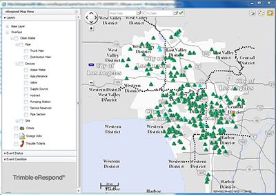 During an incident, crews can use the GIS to map the severity and extents of any spills to assist in notification, repairs, and mitigation work. The spatial data also help to fulfill requirements for reporting water or wastewater incidents to regulatory agencies.
In addition to its geospatial capabilities, the Trimble solution facilitates best-in-class incident management through tight interaction with leading enterprise and asset management systems. The system has received certification by SAP and can operate with the Oracle CC&B system. It’s also SAFE certified (Solution Application Framework for Energy and Utilities) for use with IBM Maximo software. In its 2013 MarketScope report, the Gartner Group cited the eRespond system’s unique abilities to coordinate with public emergency organizations and to scale to support water and wastewater utilities of all sizes, small and large.
From Data to Information
In concert with IBM, as the system integrator and SAP implementation partner, Trimble eRespond was integrated with the SAP CRM, SAP ECC, and SAP BI modules using standard interfaces.
The interfaces used a combination of integration technology, including SOAP-based web services, Trimble eRespond’s standard JMS adapter, and direct database connections.
United Utilities decided to create a complete model of their networks in eRespond using the tools within eRespond available for designing and managing a network model. Some utilities link eRespond to whichever system is master of their “as designed” network model data for this information.
The initial network model was created inside a period of four weeks.